


16,7 km | 20 km-effort

Utilisateur


Application GPS de randonnée GRATUITE
 SityTrail
IGN / Instituts géographiques
SityTrail World
Le monde est à vous
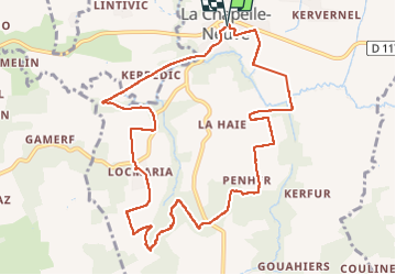
Randonnée Marche de 10,9 km à découvrir à Bretagne, Morbihan, La Chapelle-Neuve. Cette randonnée est proposée par patrickdanilo.
Randonnée Marche de 10,9 km à découvrir à Bretagne, Morbihan, La Chapelle-Neuve. Cette randonnée est proposée par patrickdanilo.


V.T.T.

Marche

Cheval

V.T.T.
Marche

Marche
Marche
Marche


sport